
Sandy Knoll Software Metes and Bounds Pro 5.3.0
- کاربرد : نرم افزار ایجاد پلات نقشه
- نسخه :Version 5.3.0
- نوع فایل : نرم افزار
- زبان : انگلیسی
- سیستم عامل : Windows 32 & 64 Bit
- تولید کننده : Sandy Knoll Software
- سال تولید : 2018
توضیحات
نرم افزار Metes and Bounds برنامه ای برای ایجاد پلات نقشه و انجام محاسبات مختلف بر روی آن هاست. کار با این برنامه بسیار راحت بوده و کاربر قادر خواهد بود با استفاده از wizard موجود و پاسخ به سوالات طراحی شده در ارتباط با نوع طرح، که برای تعیین تنظیمات پیش فرض پروژه در نظر گرفته شده اند، فرآیند گام به گامی را پشت سر گذاشته و به آسانی پلات مورد نظر خود را ایجاد کند. پشتیبانی از فرمت های DXF, KML و CSV برای فایل های ورودی و همچنین تهیه خروجی، امکان افزودن آیتم هایی از قبیل متن، برچسب، تصویر و یا عنوان به نقشه بعلاوه امکان تنظیم دقیق خطوط، منحنی ها و گوشه ها در نقشه های پلات فراهم شده است. علاوه بر تهیه پلات ساده از نقشه ها، یکی از کاربردهای Metes and Bounds امکان محاسبه مساحت نواحی مختلف است. برای این کار ابتدا از طریق مکان یابی محل در Google Earth اطراف ناحیه موردنظر را تعیین نموده و سپس با استفاده از این برنامه می توان اندازه دقیق را بر حسب پارامترهای مختلف فوت، متر مربع و ... بدست آورد.
قابلیت های کلیدی نرم افزار Metes and Bounds:
- انجام محاسبات برحسب فوت مربع، جریب و هکتار
- فرم ورود اطلاعات برای وارد نمودن منحنی ها و داده ها
- کار بر روی نقشه به صورت لایه بندی
- امکان تکمیل خودکار فرآیند طراحی
- پشتیبانی از انواع اندازه گیری و استفاده آسان از ابزارهای اندازه گیری
- امکان تخمین فاصله بین دو نقطه
- افزودن اطلاعات به صورت برچسب
- پشتیبانی از فرمت های DXF, KML و CSV برای فایل های ورودی و خروجی
- و ...
Description
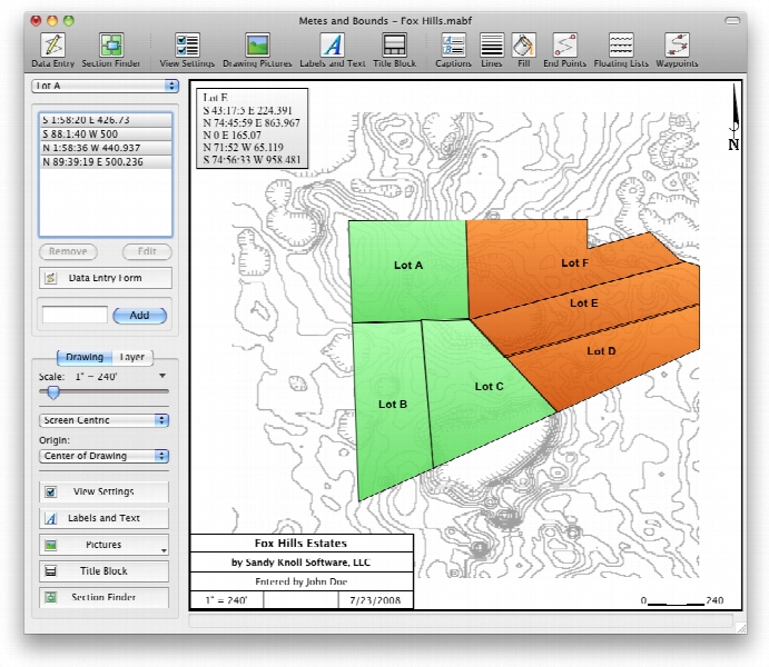
As the name suggests, Metes and Bounds is a program that can create plot maps and perform various calculations for perimeter distance and more. The program comes with a drawing wizard that helps create new plot outlines.
The app has a simple interface that includes a bunch of tools and focuses on the current drawing. The aforementioned Drawing Wizard asks you several questions about the type of plan you want to create and based on the provided answers, the wizard presets some of the values to help accomplish your goals.
Some items can be added to the plans, such as pictures, labels and text, as well as a title block.
Lines, curves and corners may be added to the drawing by specifying the exact position, orientation and distance from another point.
The program can work with multiple layers in the same drawing, providing options for using a scaled background image, such as a section or topographical map.
The bottom line is that Metes and Bounds is a nice tool that can come in handy if you often work with land plots. Less experienced individuals shouldn’t have any problems while working with this utility, thanks to its intuitive interface.
Here are some key features of "Metes and Bounds":
- Perform calculations: Square Feet, Acres, Hectares, perimeter distance and more.
- Easy to use data entry form: Enter lines or curve data.
- Layers: Layers allow you to have multiple deeds on a single drawing. Layers can be free floating or locked to a common starting point.
- Metes & Bounds will calculate if the survey closes or not. Calculate closure errors.
- Auto-Completion of drawing. If you're missing the final segment of your land plotting data, let our Metes and Bounds land plotting software finish it for you. Have a bad or missing call? Enter a question mark (?) for the call and let the software find the missing call for you.
- Multiple measurement types: Data can be inputted using Feet, meters, rods, chains, varas and many other measurement types
- Easy to use measuring tool. Estimate the distance between any two points on the screen.
- Automatic labeling: Each line can be automatically labeled with the length and call. End points can be marked for easier recognition. End points can also be labeled with information like the interior and exterior angles.
- Create custom labels and backgrounds. Labels can be rotated in 90 degree increments. Drawings can include a call list:
- Backgrounds can be set to scale with your plot drawing.
- Split a single plot into multiple plots. Split the plot by hand, or choose a starting point and let the Metes and Bounds software find the nearest halves automatically for you.
- Create section drawings.
- Exporting: Metes and Bounds data can be exported as a DXF file, KML File, CSV file and more.
- Printing: Printouts can include borders, call list, north arrow and title block.
- Real-world X,Y coordinates. Export real-world X,Y coordinates for integration with other mapping software such as GIS software.
- Custom X,Y points. Use custom X,Y points to mark and label unique land features on the metes and bounds drawing.
- Real-world Latitude and Longitude coordinates. Enter the latitude and longitude for a plot's POB and let the metes and bounds software calculate the latitude and longitude for each of the other end points.
- Waypoints to metes and bounds calls. Convert a set of waypoints, x/y or Latitude/Longitude based, into a list of metes and bounds calls.
- Enter Waypoints and Tracks. Add GPS waypoints and tracks to your drawings. Import GPX and KML files. Make calculations like the distance between two waypoints.
برای اطلاع از طریقه نصب به فایل How to Install.txt رجوع شود.
